David's Astronomy Pages
Notes - Session 559 (2013-12-28)
Notes
(S557)
Notes
Main
Home
Page
Notes
(S559)
David's Astronomy Pages
|
Notes (S557) |
Notes Main |
Home Page |
Notes (S559) |
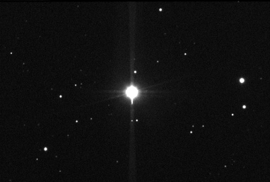
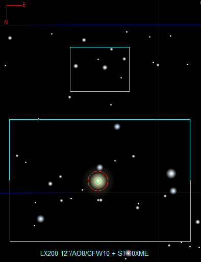
Discrepancies have been noticed in the Guide
Calibration calibration results reported by CCDSoft for the Main Imaging Chip
and Guiding Chip of ST-10XME camera.
The results are not in line with a 7.4/6.8 ratio as expected (guide pixel size
[TC-237] / main chip pixel size [KAF-3200]). This is of concern since I
normally calibration using the Main Chip and plan to autoguide using the Guide
chip. This is on the basis that results are automatically corrected by CCDSoft
for different chips and not problem have been noted in the past.
It's not absolutely clear that the current discrepancy will produce any
unexpected guiding results - it could just be a reporting issue/bug relating to
selecting "SBIG with AO (ST-7/8/9/10/2K/4K, STL)" camera. However to
eliminate any property issue with the Guide Chip itself a series of measurement
were made in the vicinity of the star HIP 22449.
Main Chip
- Pixel Size (Main Chip) : 6.8 micrometers (from KAF- 3200E spec)
- Image Scale (Main Chip) : 1.328 arc sec/pixel at 3x3 binning -
equivalent to 0.4427 arc sec/pixel at 1x1 binning
Guide Chip
- Pixel Size (Guide Chip) : 7.4 micrometers (from TC-237 spec)
- Image scale on Guide chip: 0.962 arc sec/pixel at 2x2 binning -
equivalent to 0.481 arc sec/pixel at 1x1 binning
- Calculated Pixel Size (Guide Chip) : 7.39 micrometers (from 0.481/0.4427 *
6.8)
Although a star-field was select which would
show several stars on the Guide Chip, it was not possible to get a plate
solution for the Guide Image, and therefore the image scale was manually
determined)
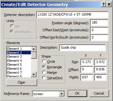
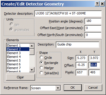
Guide Chip Placement
- Centre-to-Centre Chip Distance 9.19mm (ST-10XME Specification)
- Apparent Centre-to-Centre Distance : 9.98 arc mins based 9.19mm distance and
0.4427 arc sec/pixel image scaling.
- Measured Centre to Centre Distance : 10.8 arc mins
- Inferred Actual Centre-To-Centre Distance: 9.95 mm
Measured Centre-To-Centre Distance is greater than that expected from the
specification and expected by the "standard" Field Of View reference
for "SBIG ST-10E + ST-237" in TheSky. To get the correct
placement of the Guide Chip the Field of View Reference was updated to widen the
offset between Guide and Main Chip. A slight lateral correction 0.25
arc min was also required to get the best corrected FOV representation of Guide
Chip relative to Main Chip.
| Image on Main Chip
(3x3 binning, 75% size) Image Scale 1.328 arc sec/pixel (from Plate Solution) |
Image on Guide Chip
(2x2 binning, 100% size) Image Scale 0.962 arc sec/pixel (from Manual Measurements) |
|
|
|
|
| Main Chip CCD Image (75%
size, North Down) 10s exp, 3x3 binning, C Filter 2013-12-28 21:59hUT (#559003) 12" LX200R (at f/10.4) + ST-10XME |
Guide Chip CCD Image (75%
size, North Down) 5s exp, 2x2 binning, C Filter 2013-12-28 21:59hUT (445) 12" LX200R (at f/10.4) + ST-10XME |
|
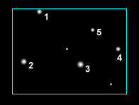
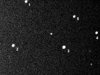
Separation distances between pairs of stars were
determined |
|
|
| FOV original | FOV after correcting Guide Chip Offset | |
|
|
|
| Guide Chip Offset - Original | Guide Chip Offset - Post Adjustment | |
|
|
Back to Top
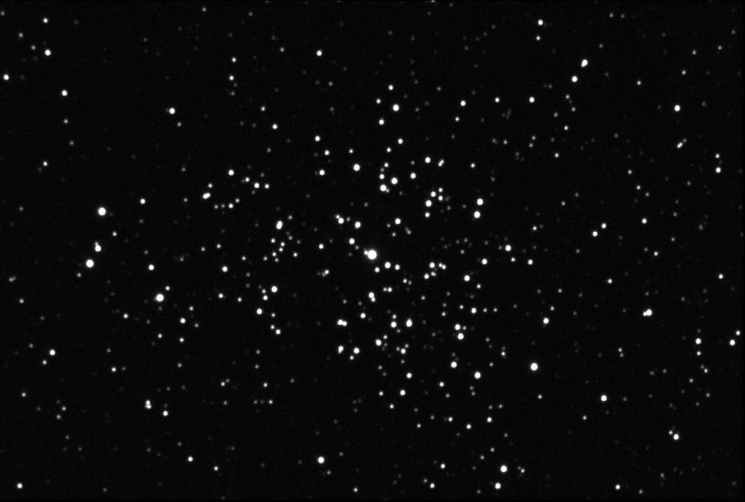
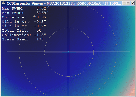
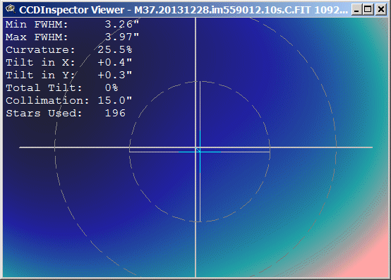
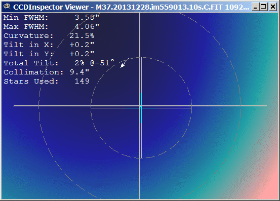
3 frames covering a rich starfield (150-200 stars) area of M37 where analysed to assess collimation of the LX200 scope. The collimation was determined to be fairly good - between 9.4 and 15.0". Whilst it might seem a slight improvement could be made, probable flexure in the optical train is likely to limit the overall success of any attempted tweak. Indeed a tweak is as likely to make things worse as much as better.
|
M37 stacked image (3 frames) |
|
|
|
CCD Image (75% scale) 3 x 10 sec exposure (average combine,), 2x2 binning, C filter, 2013-12-28 23:27hUT (#559009-13) 12" LX200R (at f/10.4) + ST-10XME |
|
Collimation assessment using CCD Inspector 2.5 (CCDWare) Collimation is appears fairly good - between 9.4 and 15.0". Whilst it might seem a slight improvement could be made, probable flexure in the optical train is likely to limit the overall success of any attempted tweak. |
|
|
|
Back to Top
xxx
Back to Top
xxx
Back to Top
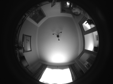
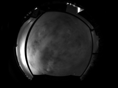
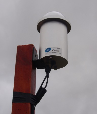
An Oculus All Sky Camera was my gift from Santa Claus this year. The camera has a 180 deg fisheye lens.
| First Light Test (Indoors) - 2013-12-27 | First Light Test (Outdoors on Tripod) - 2013-12-28 | |
|
|
|
| 0.1s exposure, 2x2 binning, 55% scale (#06) | 20s exposure, 1x1 binning, 27% scale (#00000001) | |
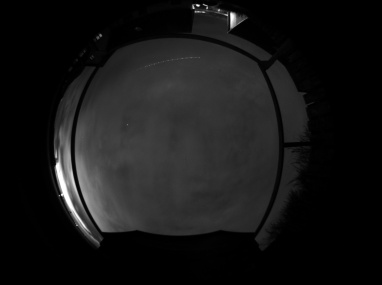
| First Light Test
(Outdoors on Tripod) - 2013-12-28 Aeroplane trail |
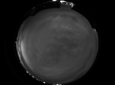
First Light Test
(Handheld ) - 2013-12-28 Handheld close to planned permanent position |
|
|
|
|
| 20s exposure, 1x1 binning, 27% scale (#00000053) | 20s exposure, 1x1 binning, 27% scale (#00000070) | |
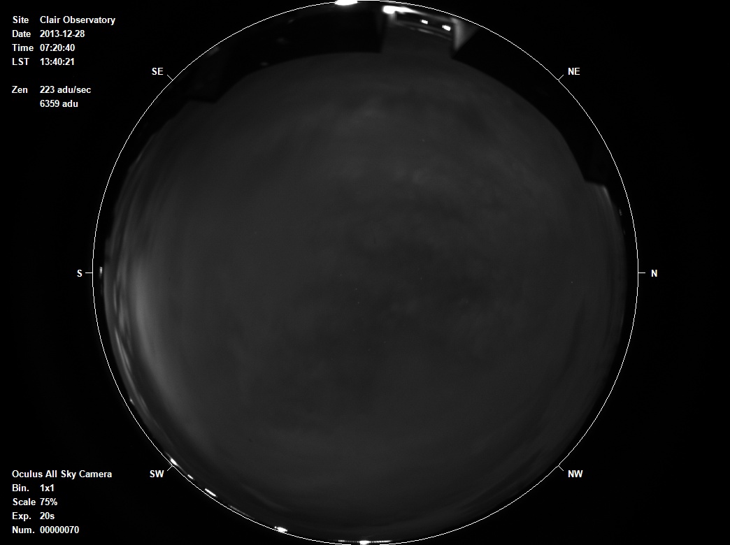
| Software written to collect series of images from Oculus Camera via CCDSoft and create JPEG image an automatically add annotation | ||
|
||
| 20s exposure,
1x1 binning, 75% scale (#00000070) Oculus All-Sky Camera, 180° lens / Handheld |
||
Back to Top
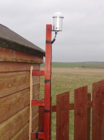
The Oculus All Sky Camera was installed in permanent position adjacent to my observatory, where it can have access to computer control, internet and power. The height of the camera dome was chosen to be at a level which was just above the highest point on the observatory roof. The observatory already has good near 360/180 degree view of the sky and generally out of direct lighting so it was going to be a good site for the Sky Camera.
A wooden post hung of the side of the shed observatory was most practical method of installation and was knocked together from existing material and put in place in under 2 hours. The USB cable for sky camera and a 12V lead for dew heater is passed through a small hole in the observatory wall and was ready for "First Light" that same evening. The next day it was found that rainwater had ran down the cables onto the observatory fall during overnight rain. The cables where tied and looped in a way that any rainwater will drain off first and the hole fully plugged.
| Pictures of Installed All Sky Camera (2013-12-29) | ||
|
|
|
|
||
Back to Top
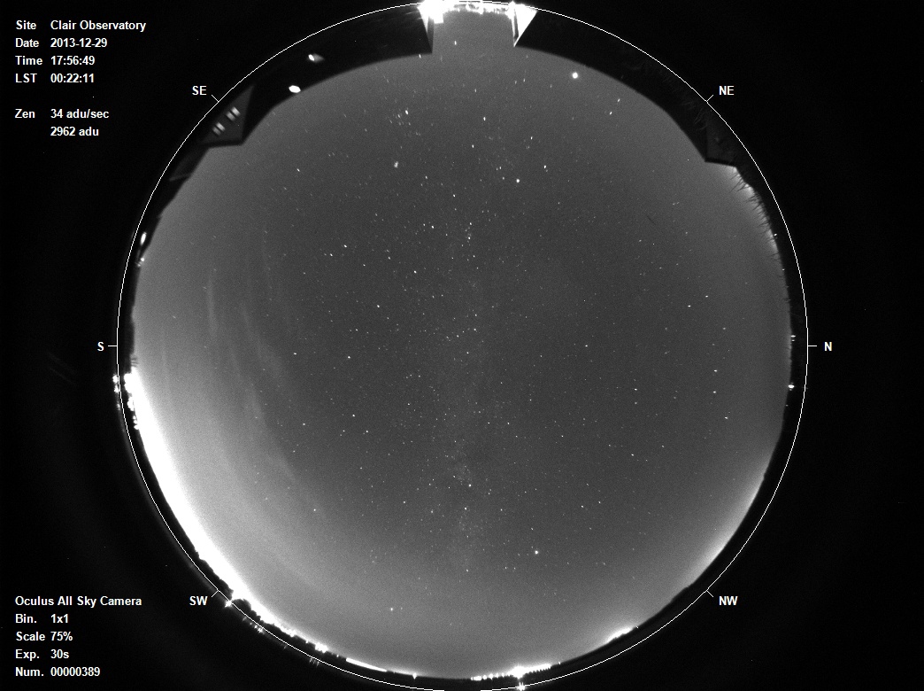
Oculus All Sky Camera was installed in permanent position adjacent to observatory, where it can have access to computer control, internet and power. Eventually an old laptop will be used to continually monitor the sky in nighttime hours, but for time being the Oculus camera is run form my main laptop when sky is reasonably clear(ish) is and I'm not using the laptop for imaging through my LX200 telescope or other use.
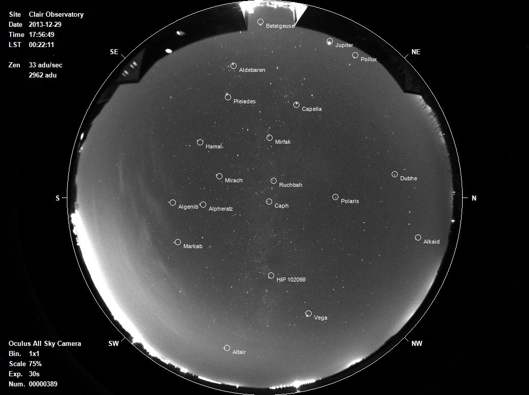
| First Light Image from
Oculus All Sky Camera in Permanent Position -
2013-12-29 (software written to collect image from Oculus Camera via CCDSoft and create JPEG image with annotation automatically added in realtime) |
|
| 30s exposure, 1x1
binning, 75% scale 2013-12-29, 17:56 UT (#00000389), LST 00:22 Oculus All-Sky Camera, 180° lens |
| Alignment Check confirms that long axis of image is aligned precisely North-South |
|
| First Light Image -
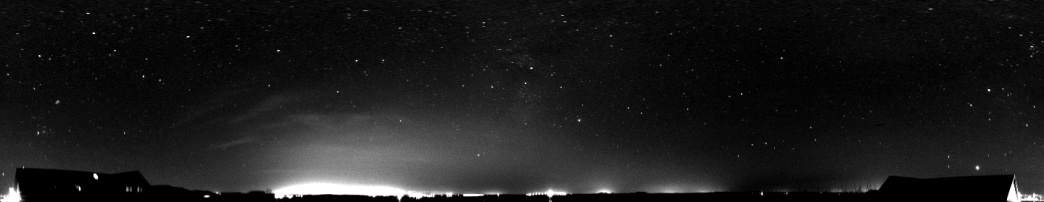
Panorama Geometry projected using IRIS software package, Sky Glow from Local City and villages |
|
| First Light Image -
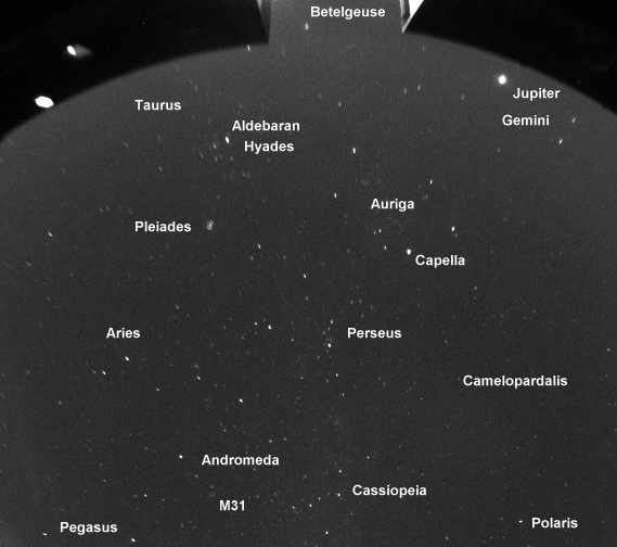
Detail (100% scale, cropped) Stars sharp at zenith but become increasingly distorted (radially stretched) at lower altitudes M31 (Andromeda Galaxy) is recognisable |
|
Back to Top
Oculus All Sky Camera use a wide angle fisheye lens. A range of calibration will be need in order optimise information from the camera. The first one being worked in calibration of the fish eye optics to allow astrometric measurement to be made., and stars/objects to be identified..
| All-Sky Calibration -
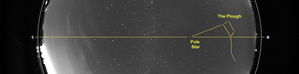
Step 1 Following Image shows the automatically plotted positions for selected stellar and planetary objects at the Time/Date of the Image. This is based on Az/Alt Positions from TheSky and assuming an idealized equidistant projection (where there is a linear relationship between Radius and Zenith Angle), and perfectly vertical alignment of camera with the zenith. That the calculated positions lie close to the position of the objects in the image is encouraging. In due course it should be possible to build a calibration routine to correct either the image or the calculated positions. (A number of paper on the internet describe calibration methods to account for radial distortion, see google search on "simple fish eye calibration method with accuracy evaluation") |
|
Back to Top
Whilst the Oculus All Sky Camera comes with software (Oculus_USB) that enable it to connect to the camera, take a series of all-sky images and combine them (or at least up to 1000 images) into an AVI file, and do a range of imaging processing tasks on a single image, it didn't do a number of crucial operations that I wanted, nor did it provide opportunity to access camera/image objects from an outside script/shell program which I'm accustomed to. This was not a particular issue as there a driver plug-in for CCDSoft called "Starlight Xpress SXV Plug In.dll" available at Starlight XPress Downloads section : http://www.sxccd.com/downloads/ccdsoft.zip, and had CCDApp2 VB.Net 2010 program which I could extend to operate the Oculus camera and the ability/fortitude to write additional software to do the tasks that I wanted.
The software tasks that I have so far written, or have still have scheduled to write are listed below :
| No | Task | Intended Benefit | Description | Comments |
| 1 | Prove operation of Oculus Camera operation from CCDSoft | Operating Oculus from CCDSoft enables Camera & Image objects to be exposed and thus controllable by external script/program. | a) Starlight Xpress SXV Plug In.dll"
downloaded from Starlight XPress Downloads section, and saved
in "C:\Program Files\Software Bisque\CCDSoft Version 5\Camera Plug Ins" folder. b) CCDSoft opened and "Starlight XPress SXV Series" selected as Camera pulldown list on Camera Control/Setup tab c) Oculus camera connected to from CCDSoft and Images taken of different exposure length either single frames or part of a series of multiple frames. Camera disconnected. |
Done. 2013-Dec-27 |
| 2 | Add All-Sky Imaging section to my CCDApp2 program | Provide a frontend for development of routines to operate the All-Sky Camera | a) Additional Button added to
CCDApp2 Main Window to access "All-Sky Camera" b) Tab added on ObsConsole Window with buttons to Connect to Camera, Take Image, Take Image Series etc |
Done. 2013-Dec-27 |
| 3 | Develop Automated All-Sky Imaging Routine |
Provide routine to take series of images from dusk to dawn each night | a) TheSky software is
accessed to find Sunset, Sunrise time (plus other things such as Sun
position and Moon position and phase) b) the routine reads the exposure time from an input field (30s default) and takes sequence of images between sunset and sunrise, transferring each image to a custom image viewer c) the routine pauses at sunrise, and waits until Sunrise this next evening to resume imaging again After the first pass routine was written and tested enhancements were then quickly added to permit automatic adjustment of exposure time as light conditions change (e.g. after sunset, before sunrise), automatic adjustment of contrast/range, automated annotation of the image, automated operations on the image (e.g subtracting the last image to creating a difference image), automated star identification and labelling. The routine suffers from a significant memory leakage issue whereby the physical memory used by CCDSoft increases with each image taken. A solution to this hasn't yet been found but for the time being a workaround is employed which automatically kicks in when CCDsoft memory reaches 500,000 KB which kills CCDSoft process, then restarts CCDSoft, reconnects to All-Sky Camera and then continues the imaging. |
Done 2013-Dec-28 |
| 4 | Automated Exposure Adjustment | Different exposures are necessary to capture appropriate detail under different light conditions (long at night, shorter during evening and morning twillight). | a) Exposure times at sunset
automatically start with 0.08 s images and lengthen to the user
specified exposure as the sky darkens. b) In the morning exposures automatically shorten as the sky lightens, eventually reaching 0.08s (from trying different exposure lengths 0.08s is the minimum exposure time under bright conditions, less than this (actually less than 0.079s) the image quality significantly deteriorates. Routine does this by looking at the Sky ADU value in an area around zenith and then adjusts exposure factor so that ADU is less than a specified amount. To preserve the overall imaging frequency (at say 1 frame every 30s or so) the routine is paused by the length of time the exposure is shortened by. SO with 30s standard exposure, morning/early evening exposures of 0.08s are followed by a pause of 29.92s duration. Tests show that sky does brighten informally when there is moving cloud near the horizon where sun is rising or at zenith, which produced undesirable brighter and darker frames. The routine was adjusted so that exposures once shortened were lengthened again. |
Done 2014-Jan-02 |
| 5 | Asynchronous Camera Operation |
Asynchronous camera operation allow a image to be analysed, displayed, annotated and further manipulated whilst the next image is being taken. | a) imaging routine adjusted
to place Camera.Asynchronous = 1 command before images with exposures of >= 15s b) after processing/display is completed on the previous image the routine then waits for the camera to finish taking the next image before proceeding. Routine generally worked ok during initial tests, but would intermittently fail to process certain frames or mix up the file renaming section. Eventually this was tracked down to a particular condition where camera has finished taking the next image, before processing/display of the previous image had finished. The routine was updated to recognize this condition and act appropriately. Whilst this improved the situation failures still occasionally occur which continue to be investigated. |
Done but
with some continuing issues 2014-Jan-09 |
| 6 | Annotated Image Display | Appropriate annotation of the AllSky image enhances its value as a record of the sky and any accompanying atmospheric or astronomical event. | a) Image displayed in
ImageViewer at a default scaling of 75% (this presents the original 1x1
binned image of 1392 x 1040 pixels in a more convenient sized image that
is 1044x780 pixels) b) The Sky View (180 deg) is surrounded by a white outer circle representing the horizon, beyond which a thick 200 pixel wide Black Circular line is used to cover up unwanted glare from approaching daylight or bright lights. c) cardinal compass points marked & labelled. Black margin added at top and base of image to facilitate posting of E and We compass direction. d) Location, time/date of image (LT, UT and LST) added to side of image along with details such as image number, exposure length, binning, zenith brightness e) brightest stars in image (not covered by clouds) are labeled Enhancements were subsequently added to show key weather station data (wind, temperature) and star positions/names and optionally constellation lines. |
Done 2014-Jan-02 |
| 7 | Image Calibration (incl fisheye lens projection) | Inage calibration allow specific X/Y position in the image to be converted to Az/Alt position and vice versa. | a) First pass involved
orientating the long axis of the camera's chip in an approximately N-S
direction and assuming idealized
equidistant projection (where there is a linear relationship between
Radius and Zenith Angle), b) calculating expected Az/Alt position of a list of bright stars based on image time/date (LST) and site location using TheSky, camera orientation c) matching the expected Az/Alt position to the nearest star-like object in a number of cloudless images (with different LST the image and exporting results to a table. d) using the mismatch between simply calculated star positions and actual star positions to define the precise orientation of the camera, precise zenith position in the image and a polynomial equation (3 terms) to more accurately convert between radial distance and zenith angle (90-Altitude) |
Done 2014-Jan-02 |
| 8 | Record Annotated and Analysed Image Files as JPEG's | JPEGs provide a convenient and ready access for viewing allsky image the next day, for analysis at a later date or for building a AVI video file | 4 jpeg images are saved for
each FITS image taken - Normal Image at 75% scale with star labels - Normal Image at 75% scale without star labels - Normal Image at 50% scale without star labels - Difference from Last Image at 75% scale |
Done 2014-Jan-06 |
| 9 | FTP Upload of images to Website | Upload of all-sky images allow remote viewing of weather conditions at my observatory site and/or viewing by others with interest in All-Sky imaging. | a) routine developed to
upload the current annotated image in view to the my astronomy website b) not yet complete - automate the upload of allsky image at regular time intervals c) not yet complete - create a web page to display latest and recent images of the sky, including an animated dislay of recent images |
In progress 2014-Jan-17 |
| 10 | Weather Station Data | Understanding of sky/cloud changes might be enhanced by a corresponding understanding of changing weather station data (and vice versa) | a) Image acquisition and
display routine updated to access Weather Station data using method
already established in CCDApp2 program for regular CCD imaging. Involves
reading Port 4001 for weather data records written by a Weather Station
repeater program residing on a different computer b) weather station data written to FITS files as keywords and posted on JPEG All-Sky images as annotation c) wind direction |
Done 2014-Jan-06 |
| 11 | Wind Direction Arrow | Understanding of wind patterns improved by tying cloud movements with ground level wind direction. | Wind direction marked as
arrow on the circumference of the AllSky view. Initial tests show that the wind direction from weather station's wind vane is often very irregular and jumps around a lot. To reduce this the display is based on a 5 minute moving average wind direction. |
Done 2014-Jan-17 |
| 12 | Constellation Lines Display | Communication of star positions may be aided by showing an drawing dotted constellation lines over the top of the image | a) routine added to read in
Thomas Bisque's file of constellation lines for Astronomy Mazine (a
sequence of LINE TO and MOVE To star positions) i b) routine added to convert Ra/Dec positions of each line end point to Az/Alt values (using TheSky utilities) and then XY plot position and plot each line on the ImageViewer picture c) check box added to flag constellation lines for plotting or not plotting. The process of determing az/alt positions from Ra/Dec positions is relatively slow and to speed the routine the file of constellation lines was edited to remove constellations not visible from my site in Scotland . Despite this process is still fairly slow and the plottimg of constellations is not enabled during realtime image acquisition. |
Done 2014-Jan-17 |
| 13 | Cursor Position | Display Az/Alt, Ra/Dec at the current cursor position | Using calibration, XY is
converted to Az/Alt Ra/Dec is then calculated from Az/Alt using TheSky's Utils.ConvertAzAltToRADec routine |
Done 2014-Jan-22 |
| 13 | Az/Alt and Ra/Dec Lines Display | Display of az/alt, Ra/dec lines and elliptical lines | Not yet implemented |
Still
Pending 2014-Jan-17 |
| 14 | Meteor Mode | Meteor observation requires a faster acquisition and display mode than general All-Sky imaging | Not yet implemented.
Ideas are: - faster image rate - reduced sky area (faster download ?) - display of 100% scale images (instead of 75%) - display with higher contrast - side by side display of normal image and difference image |
Still
Pending 2014-Jan-17 |
Back to Top
| This Web Page: | Notes - Session 559 (2013-12-28) |
| Last Updated : | 2015-05-15 |
| Site Owner : | David Richards |
| Home Page : | David's Astronomy Web Site |